


| Digital Object Identifier |
| doi.org/10.36475/L.A.W.14 |
| Abbreviated Title |
| L.A.W. |
| Issue |
| Online version |
| Print version |


In This Article
Volume 8, Issue 1
What are the Applicable Norms and Principles of International Law Delimitation of the Caspian Sea?
Affiliation: World Maritime University Alumni, United Nation (Sasakawa fellow), Head of investment and
development department of Kish investment and Development Company (belong to Kish free zone), Iran
Abstract: The purpose of this research was to identify the law applicable to
the delimitation of the Caspian Sea and selecting the best approach
in this regards. In this sense, in the beginning, the geopolitical significance of the Caspian Sea in the region and the importance of the
Convention on the Legal Status of the Caspian Sea were reviewed.
In order to examine applicable law, international legal resources under Article 38 of statute of international court of justice (ICJ) and the
best current approaches, standards, principles and methods for international maritime delimitation were discussed. Furthermore, the
main source of current and past legal statutes of the Caspian Sea,
Soviet-Iranian agreement, bilateral agreement on the northern part
of the Caspian Sea delimitation and the Caspian Sea Convention
was considered. In addition, special conditions and circumstance of
the Caspian Sea coast were assessed, and the best approach for
the demarcation of the Caspian Sea, the three stage approach, was
analyzed. It is worthy to mention, this work is a compressed and
update version of my Master thesis1
at world maritime university.
Keywords: Norm of sea delimitation, Caspian Sea, International law of the sea
Language: EN
Introduction
The Caspian Sea is known as the world's largest inland water body, located in a geopolitical location, between Europe and Asia, having an area of 390,000 km2, mean and maximum depths of 208 m and 1025 m respectively (Kosarev, 2005)
. It is a source of 48 billion barrels of oil, 292 trillion cubic feet (TCF) of gas (Kalanter, et al., (2021))
, special biodiversity, and species such as sturgeons. According to the report by the Food and Agriculture Organization of the United Nations (FAO)
, “the Caspian Sea is the traditional home of sturgeon, and the main producers of caviar in the world are four states bordering the Caspian Sea: Azerbaijan, Iran, Kazakhstan and Russia”. After the collapse of the Soviet Union and the independence of three new countries, the number of neighboring countries was increased to five, Azerbaijan, Kazakhstan, Turkmenistan, Iran and Russia, and disputes arose over the legal status of the sea. since, the only way to reach the World Ocean from the Caspian Sea is via the man-made Volga-Don Canal, which lies entirely within Russian territory and connects the Caspian Sea with the Black Sea (karataeva, 2019)
, the Iran and Russia argued that Article 122 of the United Nations Convention on the Law of the Sea (UNCLOS)
does not apply, which defined enclosed and semi-enclosed seas as “gulf, basin or sea surrounded by two or more States and connected to another sea or the ocean by a narrow outlet or consisting entirely or primarily of the territorial seas and exclusive economic zones of two or more coastal States”. Although UNCLOS didn’t explain the type of “narrow outlet” whether it must be natural or artificial, Iran and Russia to reduce the risk of the presence of third parties and due to shorter coastline, insisted, the Caspian Sea is not the sea, semi-enclosed or enclosed sea and it is a lake and common property. Furthermore, Iran was not a member state of UNCLOS since didn’t ratify it and Kazakhstan and Turkmenistan have neither signed nor acceded either the Convention.
Lack of co-operation, growing disputes and unilateral action have increased opportunities for pollution, illegal fishing, and drug trafficking and illegal migration. (Zhekenov, 2020)
. However, states noticed that the Caspian marine environment became fragile, with excessive exploitation, habitat destruction, invasive species and oil pollution threatening the sea. (Tsutsumi and Robinson, 2008)
. In light of this, the Caspian Maritime Environmental Protection Agreement, known as the Tehran Agreement, was signed in 2003 and entered into force in 2006. Apart from the Tehran Convention, four protocols were signed and the uncertain legal status was one of the most important obstacles to the implementation of the protocols. In addition, the discovery of oil fields in the northern part of the Caspian Sea led to a trend of bilateralism, which Zimnitskaya and Geldern (2011)
called an innovative approach to the principle of "common waters, a divided bottom" in the region, and by 2003 the northern part of the Caspian seabed was divided by agreements between three states, the Russian Federation, the Republic of Azerbaijan and the Republic of Kazakhstan, but the agreements concerned only the seabed. Finally, in August 2018, in Aktau, Kazakhstan, five states signed the Convention on the Legal Status of the Caspian Sea
. It was a monumental achievement, as the UN Secretary-General welcomed the signing of the Caspian Sea Convention, stated "this historic document illustrating the importance of regional cooperation, which is fundamental to maintaining international peace and security and an important step towards weakening regional tensions”, and, Iranian President Hassan Rouhani remarked
“the signing of the Caspian Sea convention is a successful model for guaranteeing peace, stability, friendship, good neighborliness”. From a security point of view, the agreement actually provides regional security since countries have agreed to ban the presence of third parties in the Caspian Sea and brings various political, environmental and economic benefits to the states, as Janusz-Pawletta (2020)
believed it is an important factor for sustainable development since it regulates the environment protection and access to energy. However, there are some negative views toward the convention which for instance argued, some Articles of convention act as obstacles to the exploration of oil and gas in the Caspian Sea and Iran and Russia intentionally put these Articles, such as article 14(2) which declared “The Parties may lay trunk submarine pipelines on the bed of the Caspian Sea, on the condition that their projects comply with environmental standards and requirements embodied in the international agreements to which they are parties” (Gurbanov, 2018; Bayramov, 2020)
. In parallel, Prichin and Anschchi (2019)
argued the new convention only gives environmental surveillance powers to Russia and Iran. Besides that, there were important issues of dispute that needed to be resolved.
Article 8(1) of the new convention states “Delimitation of the Caspian Sea seabed and subsoil into sectors shall be effected by agreement between States with adjacent and opposite coasts, with due regard to the generally recognized principles and norms of international law, to enable those States to exercise their sovereign rights to the subsoil exploitation and other legitimate economic activities related to the development of resources of the seabed and subsoil” and it does not clarify what norms and principles of international law should be applied. In the same vein, Article 7(3) and Article 9(1) of the convention declared delimitation of internal and territorial waters and delimitation of fishery zone between States with adjacent coasts shall be effected by agreement. Additionally, Iran subjected ratification of the Caspian Sea convention to the delimitation agreements. Since “each maritime delimitation case differs and flexible consideration of relevant factors is required to achieve an equitable result” (Tanaka, 2019)
and delimitation of maritime zones is crucial for peaceful relations between neighboring States (Lagoni and Vignes, 2006)
, defining the norm and principles of delimitation will be a vital factor for the success of the new convention.
1. THE NORMS AND PRINCIPLES OF INTERNATIONAL LAW FOR DELIMITATION
Before discussing international rules, standards and principles of maritime borders, it is appropriate to introduce the sources of the law of the sea. It is generally accepted that the source of the recognized international law is reflected in the Article 38 of the ICJ Constitution
which states:
“he court whose function is to decide under international law such disputes as are submitted to it shall apply:
- general or particular international conventions, establishing rules expressly recognized by the contesting states
- international custom, as evidence of a general practice accepted as law;
- the general principle of law recognized by civilized nations;
- judicial decisions and the teachings of the most highly qualified publicists of the various nations as subsidiary means for the determination of rules of law”.
This Article lists sources of formal and material international law (Fitzmaurice, 2017)
.one of the most important one are legal procedures by which legal rules come into existence. Customary law has two categories of public and private or local customary law. Since treaties are binding only on the parties involved, the rules of common law are binding on all countries in the international community as the International Court of Justice (ICJ) stated: “General customary law must have equal force for all members of the international community and cannot be subject of any right of unilateral exclusion.” (The North Sea Case, 1969)
. Tanaka (2015)
argued that, customary law comes from two elements, namely an objective element, state practice, and a subjective element, judicial opinion. In addition to state practice, a treaty may also generate a new common law rule. Roach (2014)
listed in his study the rules of the UNCLOS that the international court has recognized as customary international sea law, such as Article 15 and 83. The boundary delimitation is governed by legislation, which over time has been expanded by codification given in treaty provisions. Its growth has also been substantially aided by the jurisprudence of the ICJ and ad hoc tribunals. Miron (2020)
believed “The law on maritime delimitation is often characterized as judge-made law”. In this regard, the source of maritime delimitation was considered as follows.
1.1. Conventions Provisions Concerning Maritime Delimitation
Three conventions relating to maritime delimitation of sea are, the 1958 Convention on the Territorial Sea and the contiguous Zone
(hereinafter referred to as TSC), the Convention on the Continental Shelf and the Convention on the Law of the Sea (UNCLOS) 1982. Paragraph 1 of Article 12 of TSC and Article 15 of UNCLOS provided the triple rule of “agreement – equidistance (median line) special circumstance.” for delimitation of territorial sea. These two provisions are generally considered to reflect customary law, which is consistent by applying the median line method if the states do not reach agreement. However, the conventions did not define the special circumstances and it must be clarified during the development of jurisprudence and state practice in the field of maritime delimitation. In addition, Article 6 of the convention on the continental shelf 1958
introduced the notion of a special circumstance, similarly, UNCLOS contains special provisions, Article 74 and 83, for EEZ delimitation and continental shelf which stated: “the delimitation of the exclusive economic zone [the continental shelf] between states with opposite and adjacent coasts shall be effected by agreement based on international law, as referred to in article 38 of the statue of the international court of justice, to achieve an equitable solution.” These two Articles omit any reference to a method of delimitation. However, it is noteworthy that the fundamental procedural principle has been introduced by UNCLOS to sea delimitation is the peaceful settlement of international disputes and emphasis on an agreement in good faith as the ICJ stated:
“Any delimitation must be effected by agreement between the states concerned, either by the conclusion of the direct agreement or, by some alternative method which must be based on consent” (the Gulf of Maine, 1984)
.
The most essential implication of the fundamental rule that maritime border delimitation should be accomplished via agreement is that parties are free to choose any delimitation line they choose based on political, economic, geographic, or other considerations (DOALOS, 2000)
.
1.2. Approaches of Jurisprudence to the Maritime Delimitation
Delimitation by judicial process is a legal operation and it is based on consideration of the law and there is the distinction between delimitation based on legal rules and delimitation by states during negotiation which is based on political consideration. There are different approaches towards delimitation as is described in the following parts.
1.1.2. Equidistance
Equidistance is the predictable method and delimitation line mathematically determined. After 1958 in many cases, governments did the negotiations by considering an equidistance line and the majority of bilateral treaties on maritime delimitation used this method. However, there may be complications if one state uses normal baselines that follow the sinuosity of the coastline while the other uses a straight baseline system that connects the outermost islands, promontories, and rocks (Charney and Alexander, 1993)
. The ICJ and arbitral tribunals reduced the equidistance technique's privileged standing as the basis of entitlement to both the EEZ and the CS within 200 nautical, viewing it as a method that, in some situations, may result in inequitable and irrational outcomes.
1.1.3. Equity principles
The equitable principle stems from court jurisprudence, which is the general guiding principle. It combines two types of principles: procedural and substantive. The procedural principle is that the delimitation is done by agreement, and the substantive include equity. Cottier (2015)
believed equity has been a companion of the law ever since rule-based legal systems emerged, and it provides a path to justice if the law is unable to appropriately respond. The equitable principle as customary law became the main aspect of the law of maritime delimitation (Østhagen, 2020)
. The principle of equity and relevant circumstances has been stressed in article 59 of UNCLOS as a basis for the resolution of conflicts regarding the attribution of rights and jurisdiction in the EEZ. However, the approaches toward this principle were different as is described in the following parts.
A) Result oriented equity approach
In the North Sea Case 1969, which involved disputes of the Federal Republic of Germany with the Netherlands and Denmark as regards their continental shelf delimitation, the ICJ held “there is no single method of delimitation the use of which is in all circumstance obligatory” and court decided delimitation should be effected by agreement on the basis of equitable principle. The ICJ stated equidistance line is not appropriate due to the shape of the coasts of the Federal Republic of Germany, which was concave (Guernsey, 2000)
. In the same manner in the case of Guinea and Guinea-Bissau before Arbitration Tribunal in 1983, the arbitral decided to reject the application of the equidistance method because of the existence of geographical circumstances, such as the concave coasts of the States (McLarky, 1987)
. This approach has been called the result-oriented approach. It, focused on the equitable outcome rather than the techniques to be used and provides the international court and tribunal’s opportunity to do not bind any method and decided each case based on its own circumstance, as the IJC stated:
“The result of the application of equitable principles must be equitable and the result which is predominant, the principles are subordinate the goal. The equitable of a principle must be assessed in the light of its usefulness for the purpose of arriving at an equitable result”. (Tunisia v. Libya case, 1978)
.
B) Corrective Equity Approach
In the Libya/Malta case
of 1985, the ICJ used the equidistance method just as starting point and equity as a corrective element and shift the equidistance line based on special circumstances. This approach has been called “corrective –equity approach”. In 1993, regrading delimitation of the continental shelf and fishery zone, the court by considering Article 6 of CS convention and customary law held: “Even if it were not appropriate to apply, not Article 6 of CS convention, but customary law concerning the continental shelf as developed in the decided cases, it is in accord with precedents, to begin with, the median line as a provisional line and then to ask whether special circumstance require any adjustment or shifting that of the line” (Greenland v. Jan Mayen case, 1993)
. In this case, the court applied this approach as customary law. In the Cameron v. Nigeria case
, the court adopted a new interpretation, and since there was no particular reference to any technique of delimitation in UNCLOS, it determined that a specific method, namely the equidistance method, should be incorporated into these provisions.
C) Three Stage Approach
For the first time in the Black sea case 2009 between Romania and Ukraine, the ICJ used new formula which called “three-stage approach”. Based on this approach, establishing the equidis tance line is first stage, then court will check the relevant circumstances in order to adjustment of provisional line and at the third stage, to avoid any inequality the disproportionality test has to be applied. This approach also called the equidistance/ relevant circumstances method. This approach has made maritime delimitation more predictable and transparent (Miron, 2020)
. However, till now courts have not established any recommended technique for disproportionality test calculation (Fietta and Cleverly, 2016)
. In 2012, the ITLOS used this approach and held: “At the first stage it will construct a provisional equidistance line, based on the geography of the casts and mathematical calculation, it will proceed to the second stage of the process, which consists of determining whether there are any relevant circumstances to adjustment, if so, it will make an adjustment the produces an equitable result. At the final stage, the tribunal checks whether the adjusted line results in any significant disproportion between the ratio of the respective coastal lengths and the ratio of the relevant maritime areas allocated to each party.” (Bangladesh v. Myanmar, 2012)
. Additionally, the ICJ, and arbitration used this approach, the ICJ in the Chile v. Peru case
, and the arbitration in the Bangladesh V. India case. Nowadays, international courts have transited from the result-oriented-equity approach to the three stage approach (Chuanxiang, 2016)
.
1.1.4. Relevant Circumstances
The relevant circumstances are those circumstances are taken into account in the delimitation process by States and the courts. Most relevant and dominant geographical, historical, political, economic, socio-economic, security, and other kinds of factors can be taken into account by states,
open-ended categories, since till today not only the conventions, especially Article 6 of the convention on the continental shelf and Article 15 of UNCLOS but also courts did not provide the list of circumstances. In the Angelo – French case the United Kingdom argued it does not mean there is no limitation for a special circumstance under Article 6 of the convention on the continental shelf but the court rejected this claim (Evans,2018)
, which means there is no limitation. However, DOALOS (2000)
, stated “in the delimitation based on legal rule the international court has interpreted “relevant” criteria and factors as directly relevant to the delimitation, therefore, of a non-political or economic nature.”, Consequently in the negotiation stage, states have the flexibility to influence the outcome in favor of their interest.
2. SOURCES OF INTERNATIONAL LAW FOR THE CASPIAN SEA DELIMITATION
2.1. Agreements
To find the applicable law of maritime delimitation for Caspian Sea, ascertaining whether there is any pre-existing agreements relating to the maritime delimitation is crucial, in this regard Soviet-Iran agreements, additionally, delimitation agreements of the north part of the Caspian Sea will be reviewed.
2.1.1. Soviet-Iran agreements
During the era of the USSR, the Caspian Sea was treated based on two agreements between Iran and USSR, the first one was signed on 26 February 1921(Mehdiyoun, 2000
, and two parties were given equal shipping rights in the Caspian Sea as well as the right to fly their flags on their commercial vessels and both reaffirmed the 10-nautical mile fishing zone in the Treaty of Commerce and Navigation agreement in 1941 (United Nation, Treaty Series, 1959). After the disintegration of the USSR, these two agreements were inadequate to deal with the presence of the new littoral states and their demand toward delimitation and consequently exploration and exploitation of natural resources in the seabed of the sea. The treaties of 1921 and 1940 solely addressed navigation, fishing, and trade and did not clarify the legal status of the Caspian Sea, and neither provide an official and final delimitation line. In addition, in this period (1921-1940) the concept of EEZ and continental shelf was still some long years away, while its general acceptance in practice and being introduced in the UNCLOS 1982. In this regard riparian states took various measures, which demonstrated that they did not accept the validity of these agreements, nevertheless Turkmenistan in its letter to the UN general assembly (UN General Assembly, 1998)
accepted agreements. Additionally, by increasing the heated contention in the region, Iran, and Russia as a party to these agreements, in their joint statement (UN General Assembly, 2000)
stated: “until the new legal status is devised for the Caspian Sea, these two treaties retain their full legal validity”. This statement gave the valid duration to these agreements till introduction of the new legal regime, and the texts represent evidence of the Parties’ understanding as far as the establishment of future legal status of the sea is concerned.
2.1.2. Delimitation Agreements
USSR in 1970 by its unilateral action set a delimitation line on the Caspian between Iran and USSR and then divided its part into national sectors among its Unions. In 1993, this delimitation was approved by Russia for the benefit of Kazakhstan, Turkmenistan, and Azerbaijan, after disintegration of its union. Russia entered into the seabed delimitation with Azerbaijan and Kazakhstan by different agreements including the agreement between, Russia and Kazakhstan in 1998, Russia and Azerbaijan in 2002, and the Agreement on the Convergence Point of the Delimitation Lines of Adjacent Areas of the Caspian Seabed between Russia, Azerbaijan, and Kazakhstan in 2003. Regarding the above-mentioned agreements, the following matters call special attention:
- The preamble of these agreements stated “being guided by the conventional principles and rules of international law”;
- Justified equidistance line method has been used for delimitation in these agreements;
- Configuration of coast and islands has been taken into account as a relevant circumstance;
- Based on Article 2 of the agreement between Russia and Azerbaijan and Article 2 of the agreement between Russia and Kazakhstan “Development of mineral resources of the structures crossed by the line of demarcation will be performed based on the international practice applied in case of development of cross-border fields, the authorized organizations appointed by the Governments of the parties”;
- These agreements just delimited the seabed, leaving main activates such as shipping, fishing, and environment regimes to be determined later;
- All agreements have been declared illegalby Iran.
2.2. Littoral States Practice
Tunkin (1961)
believed custom norms are being formed in international practice, as a rule, and opinio juris is an essential element of customary norms. States practice can be a physical act, or what they say such as policy statements, press released, opinion of official legal advisers and Opinio Juris include public statements of states, diplomatic correspondence, resolutions adopted by the international organization and it can play a crucial role in reflecting the interest of the international community. Following the disintegration of the USSR, the political view and practices of the coastal States were contrary to each other. These views have been shown in their letters to the UN general assembly as the following table.
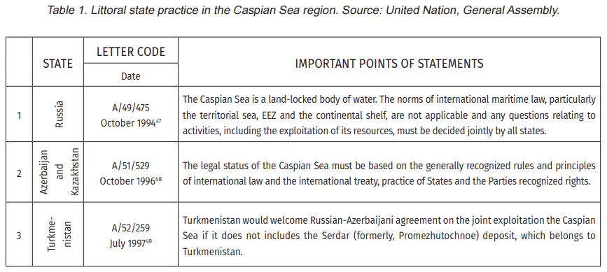
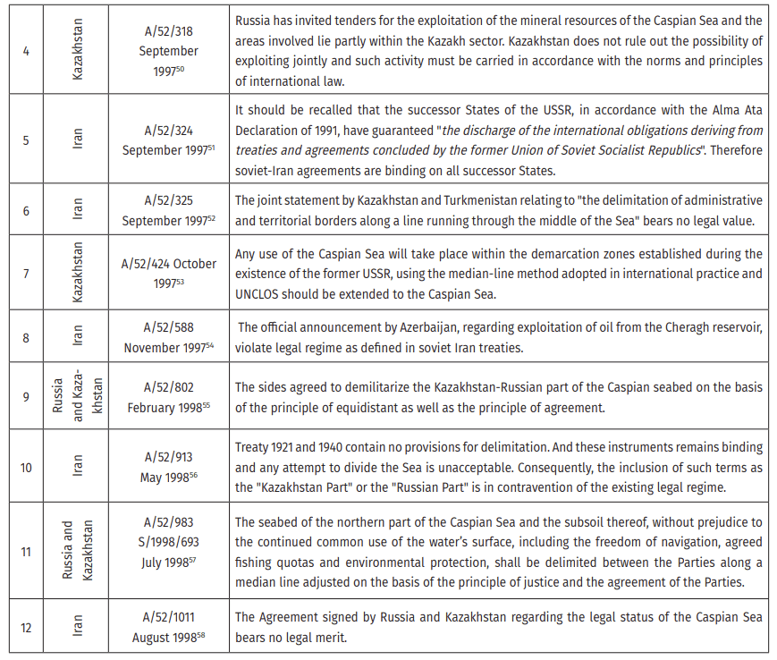
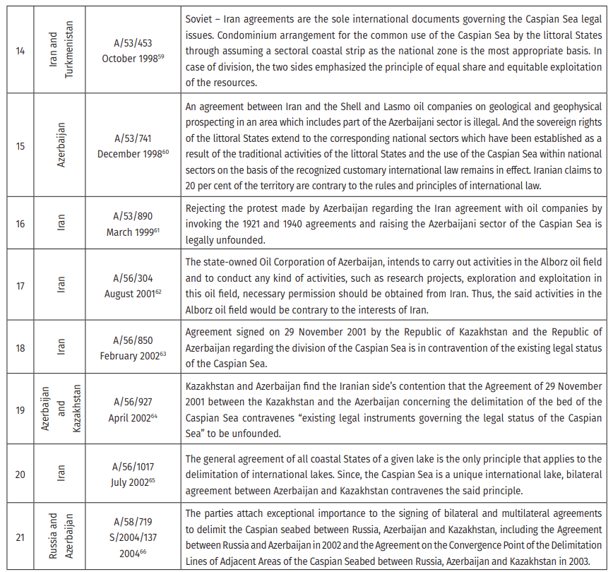
As it is shown in table 1, however, all five states had diverging approaches toward the Caspian Sea, and a considerable number of the arguments presented by states to the UN general assembly concerning delimitation, they believed the delimitation has to be done by bilateral or multilateral agreement on the bases of international law and principles.
2.3. UNCLOS 1982 and Customary Law
Regarding the applicability of the UNCLOS 1982 as a treaty source of international law for delimitation of the Caspian Sea, two issues call for brief comments. Firstly, according to Article 34 of the VCLT,
“a treaty does not create either obligations or rights for the third state without its consent”, in this vein, Some of the littoral states of the Caspian Sea are not members of this treaty, furthermore, Article 1 of the convention on the legal status of the Caspian Sea, defined this sea as a body of water which surrounded by the land territories of the Parties, nor sea nor closed sea, consequently the UNCLOS as treaty law is not applicable. However, the fact that not all coastal states are party to the UNCLOS does not preclude the application of customary international law, which has been recognized by international tribunals. To the subject matter, as before has been discussed, Article 15, 74 and 83 of UNCLOS which are related to delimitation of maritime zones, became customary international law. In addition, based on Articles 74 and 83 of UNCLOS, as customary law, delimitation must be achieved by agreement and results in equity. The doctrine of equitable principle, which is based on ex aequo et bono, is the fundamental norm of customary international law related to maritime delimitation and provides effective delimitation by agreement (Kwiakowska, 1988).
2.4. Convention on Legal Status of Caspian Sea
The Caspian Sea Convention establishes only basic concepts, and other contentious topics have been postponed to future treaties. Reviewing the strength and weaknesses of the convention is beyond the topic of this research, however, some points merit particular attention as follow:
- According to the preamble of the convention “the Convention is based on the principles and norms of the Charter of the United Nations and international law”;
- Convention defined maritime zones differently from the UNCLOS. The Caspian Sea According to Article 5 of its convention, is split into territorial seas, fishery zones, sectors and common maritime space;
- 15 nautical miles from the baseline has been allocated as the breadth of the territorial zone. And based on article 7, “delimitation of internal and territorial waters between States with adjacent coasts shall be effected by agreement based on the principles and norms of international law”. However, the Article does not cover the opposite costs delimitation such as Turkmenistan and Azerbaijan situation;
Based on the convention, where the coastline is indented or where there is a fringe of islands along the coast in its immediate vicinity, Straight baselines shall be used and Article 1 declared “the methodology for establishing straight baselines shall be determined in a separate agreement among all the Parties”. This means states to negotiate for delimitation first must gain approval of all stats to draw Straight baselines. However, as Schofield (2012)
stated, claim from straight baseline arise from varied interpretation of cut or indented coast, how many, how close to one another and how far offshore fringing islands need to be. In this vein, there is a lot of possibility for claim;
- Based on Article 9, 10 nautical miles-wide adjacent to the territorial waters has been defined as a fishery zone which has to be delimitated between States with adjacent coasts by agreement based on the principles and norms of international law and it does not cover the opposite costs delimitation;
- Contrary to the UNCLOS, which defined the maximum extension of the continental shelf by each state, the Caspian Sea convention named the parts of the seabed and subsoil for the subsoil exploitation as “sector” without allocation specific breadth. Nevertheless, similarly, to the UNCLOS, the seabed delimitation shall be effected by agreement between States;
- The convention is silent about the validity of the seabed delimitation agreements of the north of the Caspian Sea;
- Ratification of the convention by parties is not subject to the delimitation agreements however Iran postponed the ratification of the convention to the agreements of delimitation and defining the methodology of the drawing baseline by coastal states.
In summary, by taking everything into account, the conclusion could be drawn that the applicable law to the delimitation of the Caspian case is customary law and the sources of judicial decisions, since the Caspian Sea convention has not been entered into force and some of the littoral states are not a party to the UNCLOS. It is noteworthy, even in case of entering into force of Caspian Sea convention, the new convention introduces the same way of maritime delimitation which has been declared by Article 74 and 83 of UNCLOS, by agreement. However, Article 74 and 83 of UNCLOS did not specify any delimitation method, emphasized the content of “an equitable solution”. Regardless of whatever method is employed, the delimitation must be equitable, and to achieve equity, consideration should be given to the possible existence of special circumstance. For instance, Soviet – Iran treaties are viewed as the historical right which Iran relied on, however, based on Article 2 of the Iranian law on the exploration and exploitation of the resources in the continental shelf, declared “as regards the Caspian Sea, the rule of the international law relating to close sea are applicable”. It is obvious, the Iranian lawmakers recognized that Soviet-Iranian Treaties did not apply to the delimitation of Caspian Sea resources.
Conclusion
Over two decades, the legal regime and status of the Caspian Sea remain to be debated among scholars and politicians till the convention on legal statutes of the Caspian Sea has been signed in 2018 which the Kazakh President Nursultan Nazarbayev considered as the “constitution of the Caspian Sea”. However, this instrument just reflects a compromise trend between the littoral States since the sea bed and zones should be delimitated by agreements (Karataeva, 2019).
Unsettled delimitation of zones and seabed would lead to a variety of risks such as breach of international peace, security, and political instability, reducing economic activities, an increase of pollution and risk of losing biodiversity due to lack of environmental cooperation, obstacles for navigation, shipping and fishing activity, and unclear sovereign rights and jurisdiction. In this regard, a brief account has been given to the introduction of the issue and literature review, and in the next step, the norm and principle of international law in maritime delimitation have been reviewed. Therefore, based on an assessment of the entirety of the sources, agreements, texts, and negotiating history, as well as the state's practice in formulating their maritime claims, it is in the best interests of coastal states to engage in negotiations to reach an agreement on maritime boundary delimitation on the base of principle of customary international law, the principle of equity to secure the economic benefits and sustainability goals, that will be derived from a clear and recognized definition of the maritime zone's extension.
The negotiation stage can be planned based on a three-stage approach which is the methodology that has been usually employed in seeking an equitable solution recently. Based on this approach, a preliminary delimitation line is established first to reach an equal outcome, as DOALOS (2000) stated “Practice has shown that it is better to start the bilateral negotiations with a line and not to introduce right at the outset the notion of the relevant area, this may be prescribed for early disagreement since relevant will reveal itself in the process of the negotiation” and then at the next step relevant factors are reviewed to adjust the line to reach an equity outcome.
In the negotiation, states have the flexibility to influence the outcome in favor of their interest by applying different factors for drawing the line that they consider equitable. Without a doubt, boundary delimitation impacts and interacts with a variety of variables, including political issues, historical and cultural considerations, strategic and security concerns, main economic interests, and demographic group interests. In the case of the Caspian Sea, the configuration of coast, presence of the island, and natural resources, and historical rights can be discussed in this stage. However, regarding fishery right DOALOS advised “fisheries, in particular, are better avoided in such an agreement. As fisheries dynamics change over time, there may be a consequent need to renegotiate such issues. If included in the agreement, these issues may give rise to reopening the agreement as a whole, including its part on the delimitation. A more advisable approach, would be to deal with living marine resources separately from the maritime boundary delimitation agreement”. Finally, states assess whether the effect of the line, as adjusted, is such that the Parties’ respective shares of the relevant area are markedly disproportionate to the lengths of their relevant coast. Moreover, delimitation Agreements of the north part of the Caspian Sea, does not bear out claims that the Caspian was treated by the littoral states as a condominium, on the other hand, demonstrate that the littoral states acknowledged the justified median line for delimitation and regrading mineral resources demarcation will be performed based on the international practice applied in case of development of cross-border fields. In the same manner in other parts of the Caspian Sea, states may be aware of or expect to discover petroleum or gas deposits in regions where the boundary line passes. Various resource-deposit provisions are commonly used to deal with this problem. These could be resource-sharing clauses, resource-unity clauses, or resource conservation, management, and management clauses in future agreement in south part of sea.
| Publication Fee |
| Free-of-charge |
| Editor in Chief |
| Ioseb Kelenjeridze |
| Publishing Language |
| English |
| Georgian |

Copyright ©2022 All rights reserved